Smoke billows from a damaged pipeline on the outskirts of the Baba Amr neighborhood in Homs, Syria on Feb. 15, 2012.
Two years ago, joining a crescendo of protest around the Arab world, Syrians launched a peaceful uprising against the autocratic rule of Syrian President Bashar Assad. That dissent—met by a brutal government crackdown—has morphed into a bitter, grinding civil war between a fraying regime and a patchwork of rebel forces. The U.N. claims more than 70,000 people have died in 24 months of bloodshed, while the chaos has made over a million Syrians refugees.
(PHOTOS: Scenes from Syria’s two-year civil war.)
The world watched the conflict first through a mess of grainy YouTube footage posted by rebels and then the courageous reporting of both local and foreign journalists. Syria occupies complex geopolitical terrain and the international community has floundered in its attempts to end a war that’s already spilling across borders in the region. The Syrian opposition is seen to be disorganized and disparate, while at least one leading rebel unit on the ground has been blacklisted by the U.S. State Department for its perceived terrorist connections. Few consider a decisive military intervention, such as the U.S.’s controversial invasion of Iraq a decade ago, a realistic option.
But while the international community quibbles over how to best arm the rebels and forge peace, the fragile political consensus—the tacit compromises, the cynical bargains between elites, the networks of patronage and support—that bound the Syrian nation-state under the Assads has unraveled. On the world map, Syria remains a country. On the ground, it has devolved into a battlefield warred over by sectarian fiefdoms, guerrilla outfits, extremist militias, criminal gangs and a regime clinging grimly to its dwindling sources of power and legitimacy.
Click and drag the slider or the descriptions below the image to compare:
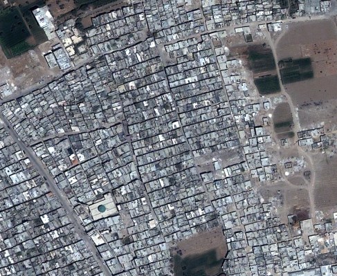

The neighborhood of Yalda, in south central Damascus. A whole stretch of the area above the local mosque has been reduced to rubble.
The disintegration of a country is a hard thing to fathom. But it can be documented. DigitalGlobe, a commercial satellite company that provides high quality images of the earth, has been tracking the Syrian war with its technology; in some instances, it has been able to compare the ravaged status quo of Syria’s present with the relative normalcy of a decade ago. The contrast is stark: whole neighborhoods that once teemed with life in historic cities like Damascus, Homs and Aleppo are now wastelands of rubble. Artillery fire has turned wheat fields and olive groves into warrens pock-marked with craters. DigitalGlobe says it has satellite imagery, too, of long slit trenches dug in the earth that have been used as mass graves.
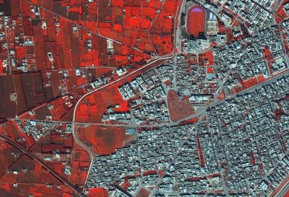
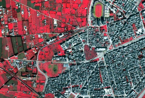
A false color infrared image of the Bab Amr neighborhood in Homs shows the damage wrought by the Syrian Army in the space of two weeks in February 2012; dark splotches scarring the rural fields, seen in the second picture, are evidence of shelling.
The company has five satellites whizzing around in orbit right now, taking high-resolution pictures for a wide range of purposes. Their cameras can zoom down to photograph even the distinct windshield of a car. In Syria, says Stephen Wood, vice president of DigitalGlobe Analytics, they have been able to monitor the “very systematic, very closely targeted” campaign of violence waged by the Assad regime against bastions of dissent.
(Photos: Photographing Syria’s Agony: The Most Moving Images of the War)
In Bab Amr, a neighborhood in the city of Homs shelled relentlessly last year by government forces, DigitalGlobe watched the devastation unfold in real time. “We could very clearly see evidence of smoke rings coming off an artillery position and the corresponding down range impact further afield,” says Wood. “We actually saw them firing on Bab Amr,” says Joe Bermudez, senior analyst at DigitalGlobe Analytics. “The level of destruction is heavily indicative of heavy weapons. And the opposition simply didn’t have that caliber of weaponry.” Infamously, the government’s February 2012 assault there led to the deaths of British journalist Marie Colvin and French photographer Rémi Ochlik. William Daniels, a French photojournalist on assignment for TIME, was also holed up then in Bab Amr—see the photographic chronicle of his ordeal, which became a TIME cover story, here.
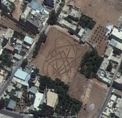
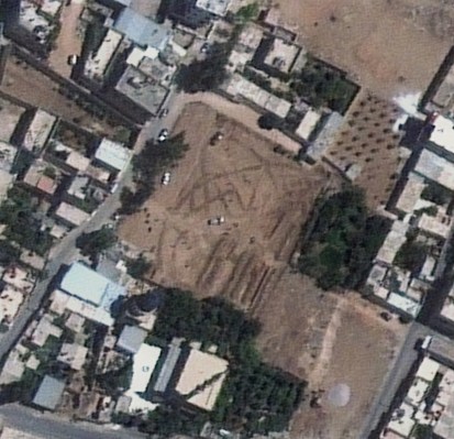
A sequence of imagery, taken over nine days, showing the digging, operation and filling of a mass grave at the Daryya Mosque, south of Damascus.
American diplomats and international rights groups have already pointed to DigitalGlobe’s imaging research of Syria in their analyses of the ongoing conflict. Wood believes the precision of their satellite technology presents a new phase in watching wars. “The industry that we belong to can shed a light of transparency on modern conflict the world hasn’t seen before,” he says.
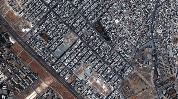
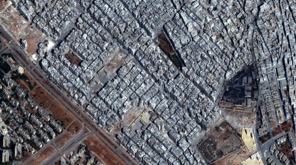
Before and after images of the Ard as-Sabbagh district of Aleppo. Many buildings here have been either damaged or wholly razed since the conflict began.
In the era of smartphones, we’ve grown accustomed to satellite imagery. Digital maps guide us daily; we toggle Google Earth with an almost cold practicality. That makes DigitalGlobe’s mapping of the Syrian war all the more chilling. When we look at our planet from above, we take for granted its human content. Not so in Syria. “It’s been a compelling experience as an analyst and as an individual,” says Bermudez, who has watched the war from his company’s headquarters in Colorado. “You start to realize how massive this event has been—and how staggering, too, the extent of human suffering.”

